Tavola Peutingeriana, Castorio, 350 d.C. (engraved, 3 colours, with wood case) - antique map reproduction

Code: FOR TAV 2

  • € 1409.41
  • VAT: 22% Included


Editor / Manifacturer: Cartageo Antica Artigiana

  Cartageo Antica Artigiana (Rufina (Florence) - Italy)  
  (source Cartageo.com)


Cartageo’s handicraftsmen has been recreating antique prints whose accuracy to the originals results in exquisite and prestigious artistic creations. These beautiful and interesting subjects are important for the historical and geographical information they offer. They embrace various historical periods in which man’s evolution has enabled him to widen his horizons by learning more and more about the surrounding environment, its representation and measurements. These works also have a remarkable aesthetic effect making them perfect for homes and offices where they may be admired and be the subject of interesting conversation. The accuracy in the production of these works is not simply a slogan. The handmade realization employs the same techniques used in the past for printing and mounting. The printing of the subjects employs the use of copper plates upon a manual press thus producing one of the main characteristics of our work: engraving. The final result allows you to feel with your fingers the texture of the material, follow the lines, writings and figures that make up the actual work. The high quality product is made even more precious because of the choice in the paper we use: it is 100% pure cotton paper, (the same that was used centuries ago), and it is mounted on pure cotton canvas. This process allows the works to be folded easily and thus can be better preserved. The mounting on canvas is followed by an aging process which using only natural substances. The “trimming” you find on the borders is the last touch giving at the maps the antique look. Upon request the works can be enriched even more by watercoloring done by masters in the field. Each subject is accompanied by a thorough historical background that facilitates the reading of the map as well as transmiting historical and cultural aspects of a given context.

Cartageo’s catalog includes approximately 180 subjects spanning from the 16th to the 18th centuries, as well as some examples nearer our own times. It includes, however, even more antique subjects like the “Tavola Peutingeriana” dating back to Roman times, circa 350A.D.. The stylistic differences varying from one epoch to the next are clear: one of the most evident is the tendency to represent a given subject with greater precision, or more realistic precision, thanks to the progress made over the centuries in the developing and perfecting of instruments of measure. Other differences can be found in the decorations adorning the maps or other subjects. From 1500 until 1700 there was in fact an evolution resulting in the progressive inclusion of scroll ornaments and ornamental figures in order to embellish the works and give them a stronger visual effect. After the 19th century there was instead a reversal of this trend: a return to the essentials and a refinement in technique. There are not only “temporal” or stylistic differences, but geographic ones depending on the depicted subject (world maps or planispheres, continents, countries, regions, cities, etc.). Cartageo also offers numerous other subjects that vary from panoramic city views to scenes of long ago pastimes to religious representations.


Category: Antique map reproduction

Dimensions: 500 x 34 cm

Availability:

Shipment Time: Prompt deli.


  • Qty:
Description

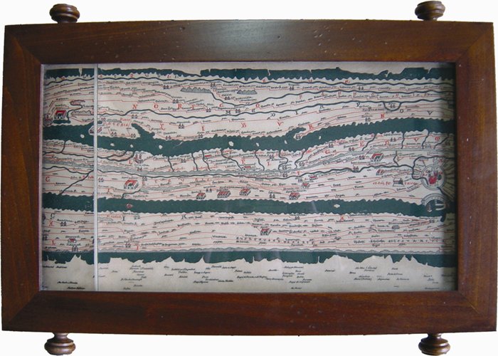
"La TAVOLA PEUTINGERIANA è, senza dubbio, uno dei pochissimi monumenti storico-cartografici che siano giunti sino a noi. Non è rintracciabile con sicurezza l'epoca in cui fu realizzato l'originale, tuttavia uno studio attento del contenuto sta ad indicare un'età imperiale alquanto avanzata, ossia non prima del 350 anno di Cristo e non più tardi dell'Imperatore Teodosio il Grande. Anche sul nome dell'autore esistono dubbi, ma i più considerano la Tavola opera del cartografo romano Castorio. In origine era di membrana arrotolata, lunga m. 6,82 x 0,34 e constava di 12 fogli o segmenti. Purtroppo il primo del rotolo andò perduto nel 1507, cosicché il segmento oggi primo è in realtà il secondo dell'originale. Questo importantissimo documento, perduto in epoca ignota, fu fortunatamente copiato verso la fine del XII o all'inizio del XIII secolo. La Carta ha preso il nome da Konrad Peutinger di Augsburg, anche se, a dire il vero, il contributo che questo signore ha dato alla conoscenza e alla conservazione della Tavola è stato assai modesto. Fu l'umanista viennese K. Celtes colui che, nel 1507, fece pervenire a Peutinger lo strano documento da lui rinvenuto in una biblioteca di Worms e si deve a M. Welser se, verso la fine del XVI secolo, vennero fatti pubblicare gli unici due frammenti della carta che tempo prima Peutinger aveva fatto copiare. Successivamente il Welser fece fare una copia dell'intera opera al pittore Giovanni Meller, inviandola al grande geografo Ortelio, in Anversa, dove venne pubblicata interamente nel 1598.Da quel momento la 'Tabula Peutingeriana' cadde in ombra fino all'inizio del XVIII secolo, testimone di una lunga serie di passaggi di mano. Nel 1741 la Carta venne montata su tela e fissata a due bastoni cilindrici sui quali veniva arrotolata, per meglio consultarla e conservarla. La Biblioteca della Corte di Vienna entrò in possesso della Tavola nel 1778, dopo che Vittorio di Savoia, ultimo detentore del prezioso documento, la cedette all'Imperatore d'Austria. La Tavola peutingeriana comprende il mondo intero, così come era conosciuto dai Romani. Lo scopo base della Tavola è la rappresentazione delle strade e delle vie di comunicazione. Che le vie di comunicazione fossero lo scopo principale della carta, ci viene indicato anche dall'abbondante sequenza di stazioni che sono disseminate su ogni tratto di percorso. Realizzata con la tecnica dell'incisione su rame a tre colori (il verde per il mare, il rosso per le vie di comunicazione ed il nero per i toponimi), presenta i segmenti montati su tela, allo scopo di migliorarne la conservazione, agevolarne la leggibilità e facilitarne il trasporto. Questa versione dell'opera rinvia a quella del 1741, essendo provvista di bastoni cilindrici e di un pregevole supporto in legno che ne agevola la consultazione."

Note

Click on the Editor/Publisher name to see some maps details and to know informations about materials and production process.

The realization process of the maps is visible in this video on You Tube.